
Marching to the Drum
Our 5:30 am alarm had been (rightly) ignored, turning it off immediately and catching a few more precious minutes – but by 6 am we knew we should be moving. Why bother doing 95% of the effort on Day 3, if we were not going to bother with the end of it? Packing up, breakfast was eschewed in favour of using the time to close some distance.
With the state of our feet hitting a fast walking/slow jogging pace was unlikely, to say the least – but we had become friends with the intense ache whenever we put our feet down and willed them to propel us forwards. Beginning at a rather optimistic, rapid pace, we covered ground quickly -passing Lochletter without so much as a pause. By 7 am things weren’t looking promising, with it now blindly obvious that unless we suddenly broke in to a Usain-Bolt-esque sprint, there was zero chance of us making the planned ferry.

This started a lively debate, eventually adjourned as we settled on the more immediate concern of finding the nearest water source, both to rehydrate from our night-time travels and to cook breakfast (a different sort of porridge this time). Whilst eating, we discussed whether we would be able to catch the ferry once it had returned to the jetty on the western bank, and whether we would be able to charter it ourselves for an additional trip. Paying over the odds to get to the east of Loch Ness did seem our only option, though we agreed it did seem unlikely to happen. We could do worse than float the idea, excuse the pun, given that we were aiming to make it to Aviemore by Tuesday (tomorrow) night.
Strolling on the quiet Affric Kintail Way was a welcome change of pace, with Scotland’s newest national trail obviously having been developed with a clear direction in mind. The paths were in good shape, well maintained and hopefully the local tourist board was reaping the fruits of their labours. We passed loads of walkers going east to west over the two days on it, so our experience was positive, and that “if you build it they will come”. Calling Gordon to pitch our plan came next, with him demurring, instead asking that we talked to him when we arrived in person at Drum, though we did hear we were not the only Challengers to miss the morning ferry slot.
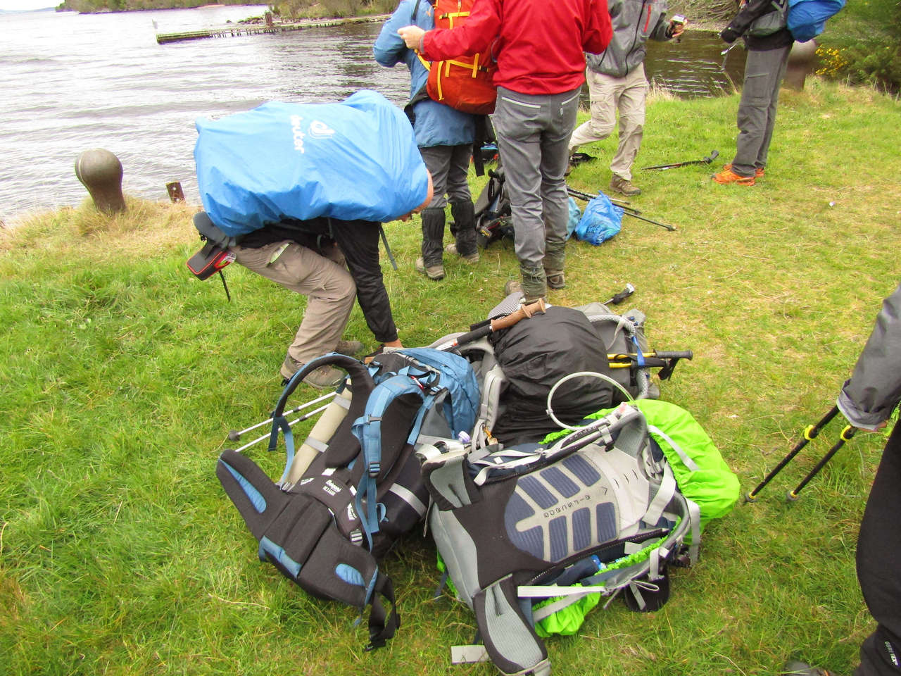
Eventually arriving in Drum at 10 am, the first port of call was the tourist information office where we asked about alternative ferry services. It seems Gordon runs the only option (I think we knew this before, but we were too tired to remember and anything was worth an ask), so it was going to be 5 pm or nothing. After seeking out and talking with the man himself, he told us our one option was to round-up the other Challengers who were likely to arrive in Drum over the next few hours, probably including the ones we passed the previous evening. If we could get him a full(ish) boat, he’d run an additional crossing. We talked amongst ourselves and decided to give it a try – we had little to do in Drum at it was, still having plenty of food in our massive food bags, so looking for people with backpacks seemed as good a task as any.
Loch Ness Ferry
Proceeding to the jetty some hour and thirty minutes later, that slim chance had suddenly become a substantial one. Challengers had started to arrive en-masse; with Americans, French, Italians and plenty of Brits shambling their way through the place – some limping, others still seemingly untouched by the ardour of their travels. We had lunch and relished relaxing for a couple of hours at jetty, content this was the best option we could get.

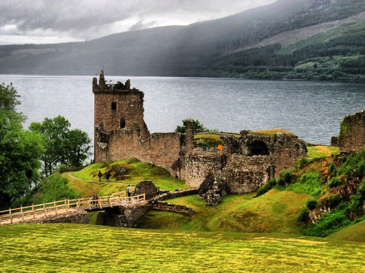
The boat itself was a pleasant surprise and sparked in to life the famous sense of Challenge camaraderie, with Challengers quickly forming a team to pass backpacks on board, stacked up in a medley of colours near the helm. I was reassured to see many similar heaving backpacks, with a clear dichotomy between those who preferred ultralight gear and those who were inclined to bring extra kit. It was interesting that the Americans preferred lighter, smaller packs, something I’ve seem to be common when browsing online “thru-hiking” (long distance hiking) communities – with the British generally preferring a “just in case” approach, likely due to how changeable the weather can be in Britain, as well as a lack of ‘on trail’ huts and layovers which tend to populate the popular Appalachian Trail. They were both surprised by how wet it had been and were tired from bush-whacking, with one suffering with his feet, and started to patch them on the jetty a few moments later. Once we departed (on our fifth mode of transport of the Challenge so far) we took some video of the Urquhart castle, a 13th-century castle which has seen better days, but still stood sentinel at the side of the loch. We would have liked to have a closer look were we in the area for longer, and made a note to return.
The eastern side of Ness
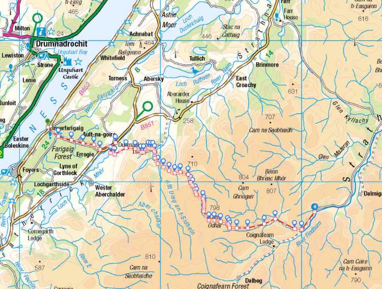
Arriving at Inverfarigaig it was surprising how a “jetty” can differ from your expectations, being that it was a precarious clamber from the boat to what looked like a grass-topped bit of scaffolding. Once most had departed, we formed a human chain to pass the heavy bags up. Talking with the others, a few were staying at a hotel on this side of the loch, whilst most, including ourselves, were looking to make distance and to slowly approach the Monadhliath mountains. By this time, it was mid afternoon, and we felt we had given ourselves a chance to get to our intended campsite, though with 28km still to go, we knew we’d have to dig in.

Continuing on to Errogie, a tiny village at which we would turn south, was done with a short road section, there being little alternative if you wanted to make inroads into the Monadhliath. We strode past most of the other Challengers despite our feet, I was even lucid enough to try a little French with our Gallic contingent. We overhauled everyone apart than an incredibly speedy chap in his 60s with a tiny pack who seemed some relation to Road-runner, and certainly appeared to have had his Weetabix that morning. It was now around 4pm, and we were intending to get to Coignafearn Lodge by night fall, a tough ask.
The section after Errogie involved a little road walking alongside Loch Mhor, where we stopped for a while to relax by the shore. It seemed a good time to change clothes and stop for some food to fuel us for the evening ahead, and the energy bars were quaffed greedily. Departing the loch we proceeded through Farraline, a farm accessible by private road, with fells to its rear and the loch in front – a beautiful setting for an outdoor aficionado. We walked through, only stopping to cheekily refill our water-bottles from the farmer’s outside tap, before striking out on rough ground, aiming for the path over the bealach which would take us towards Dunmaglass Lodge. This proved very heavy going, with the path quickly becoming indistinct until it eventually reappeared as we crested the far side of the bealach, now approaching the wood surrounding the lodge itself.
Dunmaglass lodge is a strange place. It is almost as if an oil baron with infinite money decided to build a woodland retreat, including a grand tower with a conical minaret, yet neglected to ever live there. As we approached from the heathery slopes to the west, slowly dropping down into the grounds of the estate, it struck us as odd just how new everything was, yet how little character it had. It seemed newly painted with just-laid gravel along the drive and fresh wood chippings covering the paths gently winding through its gardens. There wasn’t a single soul in sight, yet room for over a hundred. We continued through the entrance paths which didn’t seem to reflect our 50k maps, and took the wind-farm access track to Beinn Mheadhoin, now walking in wind and rain.

Perhaps surprisingly we were in high spirits at this point, even though it was approaching late afternoon and pretty dreich, we were finally “catching up” with where we were supposed to be for the night. With a line of construction traffic snaking its way down the access path, finishing their work day, we continued in the opposite direction with vigour, pushing a strong pace. G’s illness, something I know I haven’t mentioned for a while, was on the cusp of being banished, yet still present, but he was struggling massively with the pace being set, going so far as to talk about abandoning due to being in so much pain with his back. I, being a good friend, told him he was just being soft, and he should eat some jelly babies and get himself up the hill. In truth, I was concerned by the receding light and wanted to get over the tops before we got caught by darkness, but having done many hikes and carried many heavy stretchers together in the past I knew he wouldn’t threaten to quit lightly. We had already exchanged some of the heavy kit and reduced the more indulgent heavy foods, but I was concerned due to how little I felt I could do. In the end I walked slightly behind, keeping him motivated with talk of going out for dinner in Aviemore the next day as we proceeded up the access track in the grim weather, hoods up and pulled tight as we walked against the wind.

Now gaining height, the weather was becoming increasingly dull and damp, with darkness approaching as we made the 7km up the road. We left the track and struck out up the reentrant, which would take us all the way up towards Carn Odhar, a Corbett sized, fairly nondescript hill. I have a quite vague recollection of this hill, but it was soggy and required a big effort, with peak bogs everywhere, making any kind of travel inefficient, tiring and slow. Cresting the saddle and coming out from the protection of the hill, we were caught by the wind, now in full force, and we began our descent down to the far side to the nearest access track. That 2 km over the tops was very slow going indeed, but we kept ourselves moving through the now deteriorating weather, battered by wind-driven rain and navigating through hill fog. This was one of the more bleak sections of our challenge, with the intense effort needed to cross the peat bogs and navigate at the same time occupying all of our attention, with neither of us having any appetite to need to relocate ourselves in such poor terrain. The bothy bag got some solid use during this section, an item of kit I used to consider a luxury, but proved invaluable for this sort of thing – giving us a chance to change clothes, eat, read maps and patch our feet out of the gale force wind without losing warmth, or being rained on.
We navigated by compass until we hit the much smaller gamekeeper’s track, contrasting markedly with the wide access ones on the other side of the fell, used to bring wind turbines to the summit on articulated lorries. There was a real sense of isolation up there, with nobody sighted for many hours, and bleak featureless hills behind us. With it approaching 11pm we decided rather than pulling another late night, we’d camp at 550m by a ford, perhaps two hours behind where we intended to camp on the route sheet. By 11 itself we were erecting tents, away from the worst of the wind behind a good 5m bluff, before retiring to our tents to make food, aware of the need to keep up our strength. The pitch wasn’t great, uneven with tufts everywhere, but with the feet were in a bit of a state, it was clear what over 90km in the last 2 days was costing us. The possibility of a a full night of sleep was calling us like a Siren, and in a secluded site, we felt finally back on track. Looking looked forward to an easy morning of walking through the valley as we approached Coignafearn Lodge, I think I fell asleep as soon as my head hit the deck.

Bothy bags are great! I first encountered one when I did a winter skills course in the Cairngorms and couldn’t believe how useful it was in whiteout conditions.
Reading these in sequence and keeping my fingers crossed that G doesn’t have to abandon.
LikeLiked by 1 person
Hi Samantha,
Absolutely they make a massive difference, are quite cheap and can be used solo if you need space to change/re-layer, even taking ten minutes in the middle of a storm to check your map and get some food. I realise some people say ‘just use your tent’, but on uneven terrain, for short breaks, or where you need to deal with a potential casualty right now it’s hard to fault them.
I’m glad you’re enjoying them! We had quite a ‘full on’ first few days, and I won’t spoil it for you, but we certainly had to dig deep to finish some of them, especially as we were getting more tired from the lack of sleep from the first few days..
LikeLike