

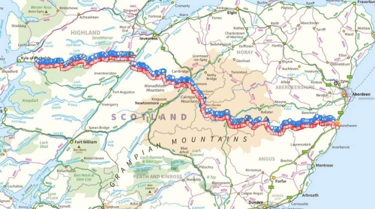
So here we are, the revisions have been made, the maps bought – and we are all ready to head across Scotland, a 300km two week hike from west coast to east. With the way the political climate is going, it may be our only chance at it, before First Minister Sturgeon decides to build a wall south of Edinburgh … and no doubt bill England for the trouble.
Part of the TGO is creating your own route, as I have detailed in this post— which you then submit to the organisers. After a couple of weeks, you get back a list of potential suggestions, and potential pitfalls along your proposed route from a “vetter”, a knowledgeable person who has done many challenges in the past.
It is worth mentioning the patience of our vetter, Roger, and his suggestions to adjust our demanding original route — gently reminding us it is a two week backpacking trip, not a weekend hill bagging ultra-marathon. Suggestions, some as simple as an alternative route up the peaks; all the way to a redesign of some of our FWAs (foul-weather alternatives, a required part of any route to keep you out of trouble), were all welcome.
We’ve ended up with a creation we are pleased with, a patchwork-monster of mountains, glens, forests and likely a smattering of mist-clad moorlandto finish it off (it is Scotland, after all).
The route itself, is detailed below in an outline for those who are either fascinated by the area, or are walkers themselves and appreciate a window in to our decision making and route finding. I do appreciate it became quite long, but I included some fantastic pics of the area we will be going through – so if nothing else, scan down and enjoy the beauty of the place.
Day 1 — Dornie
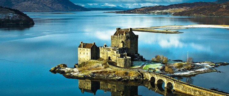
We begin with a Dornie start, somewhere we are able to get to via bus from Inverness. The beautiful Eilean Donan castle will serve as inspiration and allow us a settlement with a few shops and a pub before we leave civilisation for a few days. Looking at other blogs, routes and discussions from those who have completed the TGO more than once, it was decided a more sedate first day to get used to a full pack stuffed with food, fuel and good intentions was in order.
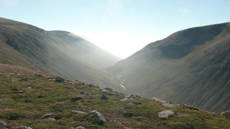
It seemed prudent to eschew the common route out of Dornie, the path alongside the River Glennan, which we expect most to be walking who leave from the same start — and instead cast ourselves amongst the fells immediately, pushing through Coire Dhunnid towards the Falls of Glomach, letting us camp as close as possible to day 2’s peaks.
Day 2 — North Glen Affric ridge
This day originally had 7km of additional ridge walking in our first submission, and would have been a dawn-till-dusk massacre-of-a-slog we’d be telling tales of till we reach 80 (no doubt about how ill advised it was). Fortunately, our vetter put us right and politely asked us to reconsider, reminding us that will be 10 days ahead of this and that crashing on the first corner wouldn’t help us.
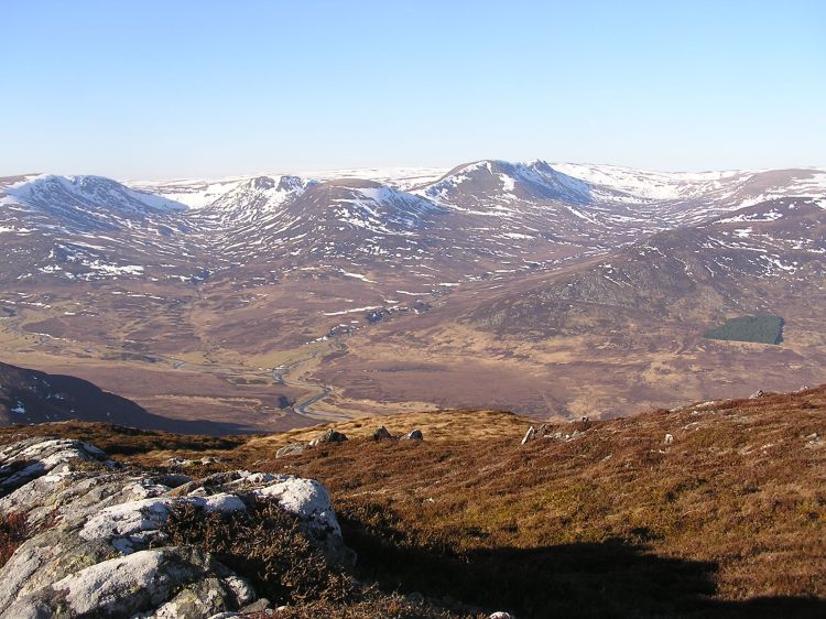
We begin with a severe pull up towards Sgurr nan Ceathramhnan, a 1151m Munro, before ridge walking most of the day at around that height towards Carn Eighe at 1183m, a peak known for fantastic views on a clear day. Rather than continue the ridge walk for a further 7.5km as originally planned — we decided to double back half a km and drop down to lower ground, a steep descent which takes us towards the beautiful Loch Affric, and a couple of hours of Loch-side ambling prior to finding a campsite and resting weary legs.
Day 3 — To Loch Ness
Probably the day with the most changes in the route, once we realised our first attempt would have us going through one of the ever-expanding wind-farms in this area, helpfully constructed in the middle of (formerly) beautiful rolling countryside.
The start of the day has a gentle meander through the lowlands of Glen Affric, shadowing the river, before striking out to higher ground at Carn Bingally, finding little hillside paths to descend, and join the Affric Kintail Way for several hours of walking through woods towards Loch Ness, and the little village of Drumnadroicht (affectionately known as ‘Drum’).
Whilst it’s unlikely there will be much spare energy in the tank after day two, there is a little fort on the hillside above Drum, meant to offer beautiful views of the Loch, which we may run in to on our descent in to the village. It’ll be on the list to visit, provided time and daylight agrees (not to mention the legs!) — before we head for our campsite, the first warm shower for four days, and a restock of supplies
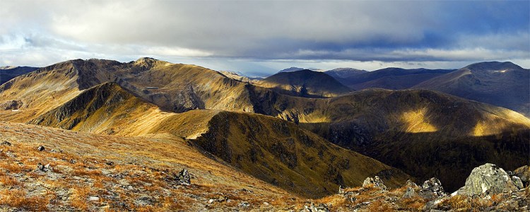
Day 4–5 — Crossing the Monadhliath
In many ways regarded as an untapped vein of beautiful countryside, with only a smattering of Munros towards the south east of the Monadhliath, this area has nevertheless become an attraction for power companies keen to place their windfarms. Several years and a whole host of developments and constructions later, it was necessary to try and plan a route around these metal creations. Fortunately, blogs exist which are dedicated to resisting the expansion of these farms, and have maps of existing developments which will let us avoid the majority of them.
Despite this blight, there are plenty of beautiful little glens in this area, and we shall wind our way over the modest hills towards Aviemore with a combination of hill tracks and stream-following, letting us take advantage of the natural protection of the land if the weather turns against us and allow us to pick a slightly easier route if the legs are painful, with a network of tracks appearing the further east you get.
One such track is the Burma Road, built by prisoners of war in the 1940s, and apparantly a fantastic mountain biking route. It’ll be our backup route if the weather becomes dreadful, with the Coignafearn Forest then heading east cross-country our main route through to Aviemore.
Day 6 — Aviemore
This was intended as a strap-the-boots-on and keep going day, before considering our need to rest, take care of the likely aching feet and enjoying some food which doesn’t need to be rehydrated.
It’s been absolutely years since I’ve spent any time there, too, so having a look around without a massive pack will be a luxury. If we are running behind, because of weather or injury, this should give us a day to recouperate and arrive ‘late’, too.
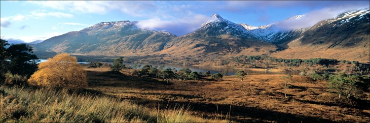
Day 7 — Cairngorms
This is where the rest day will come in handy, with day 7 starting out through the woodland to the east of Aviemore, before proceeding towards the Cairngorms proper, hopefully full of energy as we start with the Lairig Ghru and a steep ascent (either meaning the “Forbidding Pass” or “Red Pass” depending who you talk to).
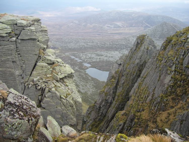
This day also should contain one of the highlights of the trip, climbing Ben Macdui, the second highest mountain in Britain, with a gentle descent afterwards to one of the quieter parts of the Cairngorms, Glen Derry.
Day 8 — Forest of Mar
Compared to the previous day this should be a relatively relaxed amble towards Sgor Mor, to the south of Macdui, something which will require going back on ourselves and heading west for a couple of km.
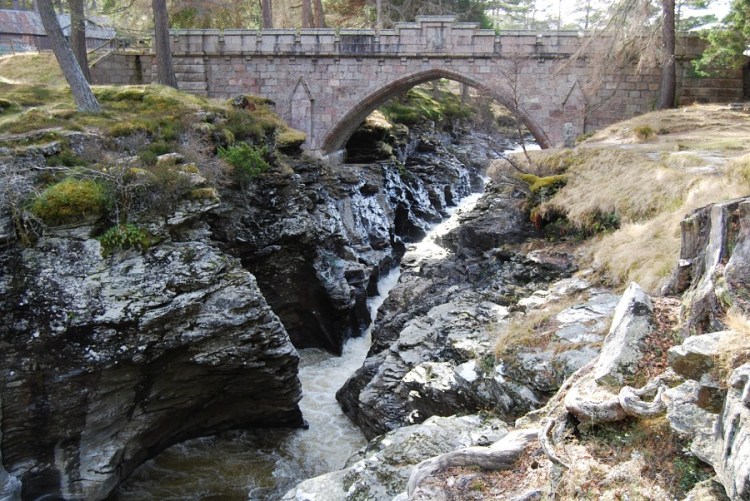
This will then take us towards the Linn of Dee, a gorge cut through by swift water, and then progresses on a level route below a green canopy into Braemar, where we have accommodation sorted.
Day 9 — Munros and Lochnagar
From the predominantly low walking of the previous day, we will set off south of Braemar towards Glen Callater, the source of so many potential routes with mountains for miles in every direction.
We’ll be heading to the east once we hit the Loch, with four Munros to bag, a challenging ridge walk providing the majority of the day — as we look down to Lochnagar from the sheer peaks above. There are a couple of mountain bothies in this area it would have been nice to visit, but the route was a little close to Braemar to bother stopping overnight at the first — and the second bothy was too far north of Lochnagar, generally a bit out of the way to detour towards. The end of this will mark the last of the 1000m+ hills on our route, and they will make way to heathery moors further east.
Day 10 — The Route to Mount Keen

This was easily the day which caused the most consternation during the planning. It has an unreasonably long slog across rough moorland, but the access paths are way out of the way from our previous day’s excursion. What this will mean is a long day of hiking over rough terrain, which I hope won’t be hindered by the weather, as otherwise it’ll be fairly bleak.
The terrain does look a lot like the Pennines in aspect, with slow rolling hills topped by the Munro, Mount Keen itself, with an approach which will no doubt quickly become boggy in a downpour. Yet the view from Mount Keen should be special, marking the last Munro of our crossing, with perhaps even the sea in sight on a clear day..
We won’t simply be shuffling off the peak and camping, which is what makes this one of the more challenging days. Instead, we’re planning to keep heading towards Tarfside, a haunt for other Challengers, which will mean a 30km high-level day and a likely dawn start.
Day 11 — Tarfside and Mount Battock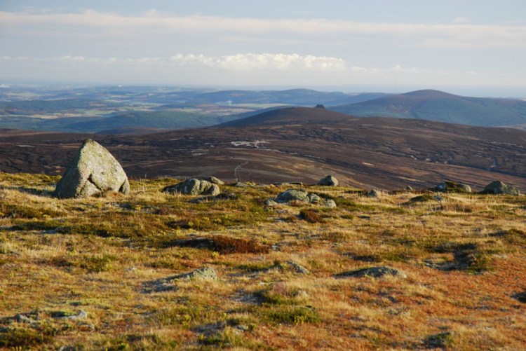
Tarfside is meant to offer a purveyor of bacon sandwiches, and I can think of nothing better to set us up for another hill day ahead, with a tracked ridge walk from Mt Een, towards Mt Battock. Depending on our stamina we can keep on ridge walking to the east if there is plenty in the tank, or descending towards Glen Dye and our likely only use of a Scottish bothy.
Anyone else is going to be pretty weary by this point, and I’m sure the extra weight of a bottle of whisky is going to come in useful by the time we get there!.. Battock (or the associated ridge to the east) will be the last of the hills as we rapidly approach the east coast..
Day 12 — Descent in to the Fetteresso

Once we wake up, I’m optimistic it’ll feel like being on the cusp of finishing, yet it is hard to expect anything but weariness after so many peaks over the previous few days. The good news is the packs will probably be light with most of the food now eaten, letting us enjoy the greenery of the Fetteresso unfolding as we tackle 20km of forest paths over the next day and a half.
In case you had forgotten about them, the Fetteresso does in fact have a wind farm in the middle of it, though thankfully only in one small part of it — we will route past that, though we are aware of some questionable access issues and whether access gates may be locked by the power company. Unfortunately, my kit list doesn’t include bolt cutters nor lockpicks, so we’re hoping for no surprises and a relatively enjoyable flat day of forest walking with a camp amongst it.
Day 13 — To the coast, and the finish.
The last day is going to be an easy half day, waking up and putting away the tent for the last time, before one sore foot is put in front of another.
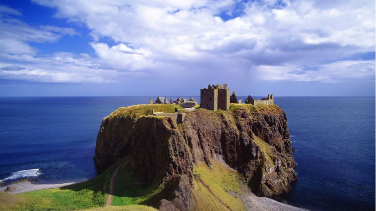
For the end point, at the start of planning the whole thing we wanted something iconic, somewhere we felt was worth it when we put our feet in the north sea — and certainly, we think we found all that and more with Dunnottar Castle, perched on a bluff, partly ruined yet still iconic.
Over 330km in total, and of course I hope we both stay free from injury and enjoy ourselves for every moment (*cough*). It is meant to be a holiday, after all!
